There is an interesting trend in the Bureau of Reclamation’s 24-Month studies projecting future elevations of Lake Powell and Lake Mead: The Bureau projects recovering elevations in Lake Powell and continued deteriorating elevations in Lake Mead.
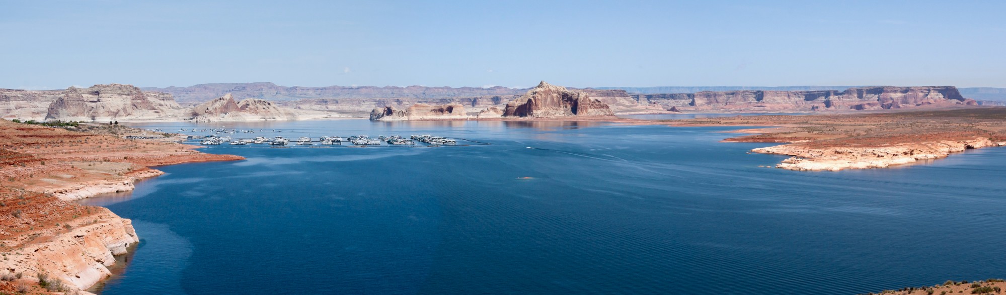
Lake Powell: A Rising Trend
Actual Lake Powell elevations in 2013 generally ran below levels forecasted by the Bureau in January 2013. January 2014 forecasts, which are generally unchanged from the December 2013 forecasts, were lower than the January 2013 forecasts. However, all three forecasts (January 2013, December 2013 and January 2014) project a turnaround in Lake Powell elevations in March 2014. The forecasted elevation in Lake Powell in the summer of 2014 exceeds the actual elevation of Lake Powell in the summer of 2013. Further, the forecasted elevation of Lake Powell in summer 2015 exceeds the forecasted elevation of Lake Powell in summer 2014.

A stock analyst would note that the elevation of Lake Powell will reach “higher highs” and “higher lows.” Looks like a recovery.
Lake Mead: A Declining Trend
Actual Lake Mead elevations in 2013 generally ran below levels forecasted by the Bureau in January 2013 until late last year. December 2013 forecasts had Lake Mead elevation falling below trigger for shortages by June 2015 but rebounding before January 2015. January 2014 forecasts are slightly below December 2013 forecasts. However, all three forecasts (January 2013, December 2013 and January 2014) project continued declines in Lake Mead elevation. The elevation in January 2014 is below the elevation in January 2013 and all forecasts project the elevation in January 2015 below the elevation in January 2014.

A stock analyst would note that the elevation of Lake Mead will reach “lower highs” and “lower lows.” Looks like a declining trend.
What Does History Show?
A look at the historical record of Lake Powell and Lake Mead elevations tells an interesting story. From 1964 (the first year of Lake Powell storage) through 2001, the January elevations of both lakes generally followed each other—rising together until the late 1980’s, falling together in the early to mid-1990s, and reaching a peak high in 2001 (the correlation between elevations was 0.92). Elevations started falling afterwards, although Lake Powell’s elevation started a recovery in 2006 while Lake Mead’s elevation continued declining. Since 2002, the January elevations of both lakes do not move as closely together (the correlation between elevations is small, 0.15).

Both the Bureau’s forecasts of future elevations and the recent historic record show that the dynamics of Lake Powell and Lake Mean elevations are different. Why?
Hydrowonk is looking into this. Once I figure it out, look for the analysis in JOW Corner in the Journal of Water (www.journalofwater.com).
MWD can store 1.5 million acre feet of water in Lake Mead and has 580 TAF stored in Lake Mead ICS account. This is only about 5% (+/-) of the 12 MAF presently stored in the lake as of last quarter of 2013.
Source: http://nwri-usa.org/documents/BillHasencamp.pdf
Good point. Lake Mead would have even lower if MWD didn’t conserve and store
Thanks
When I was part of the MWD Energy Crisis Task Force in 2001, I explored ways to reduce its spot market energy purchases to run the pumps at its five huge pumping stations running from Parker Dam to a spot just east of Palm Springs.
I asked a water planner if he could do a gravity flow water transfer from the All American-Coachella Canal into MWD’s Colorado River Aqueduct, thus circumventing MWD’s entire pumping system? His response was: yes MWD conceivably could arrange for IID to spill water from its Canal and let it flow a few short miles across the desert and then MWD could arrange to capture it in the Aqueduct. Which begs the question: cost of MWD water is free except for pumping, transport, and operation costs, but pumping is largest cost. Why didn’t MWD originally co-share the All American-Coachella Canal gravity flow system and avoid the pumping costs?
The answer seems to be that Hoover Dam needed to find a way to amortize its bonds and hydroelectric sales to the City of Los Angeles were a way to do that. This meant finding a market for the power: enter the route for the Colorado River Aqueduct which pumps water over the Mojave Desert mountains to its terminal reservoir Lake Mathews in Riverside. President Franklin D. Roosevelt also had something to do with picking the Aqueduct route as I understand it.
Of course, conflicts between farmers and cities precluded sharing the same water ditch (but what about a parallel ditch?). So amortizing Hoover Dam bonds apparently drove the route of the Colorado River Aqueduct as well allocations of water to MWD. So in the early years, Southern California paid the bulk of the bonds off for Hoover Dam.
Didn’t know that history. Interesting. Funny how things change over the long-term. Now, Hoover power contracts are coveted!
Dr. Rod
When Maven comes on board I would suggest she create a statistic of how many years of water storage does California have at any one time. To my knowledge this stat is not tracked for some strange reason. The number of years of water storage in relation maximum capacity, average capacity, etc. could be tracked. It might be able to be nuanced to how many years of storage California has for agriculture, for cities, and for the environment.
Wayne:
Your idea to express storage in terms of years of consumption is a sound one. As growth in use occurs, the same about of water in storage represents a smaller and smaller “cushion” for demand. Will look into this a bit and put up a post
Thanks
Rod
Dr. Rod
The amount of water storage in years of consumption won’t be easy to calc.
First, there are two systems — SWP and CVP
In both there is some that is dedicated to irrigation districts
There are different formulas for contract water in each.
Some reservoirs like New Melones are now primarily green water and only ag when there is a surplus — so that storage should not count towards what is available for cities. But the DWR website with its percent of capacity and percent of average for each reservoir gives a misleading impression that the aggregate of water in all those reservoirs is available for cities when it is not.
You have the math wonk skills to break this down and possibly to pull out of your head an algorithm or formula
Let’s say California needs to have 5 years of storage after looking at the stats on the AVERAGE RECURRENCE INTERVAL OF PRECIPITATION
HERE: http://documents.clubexpress.com/documents.ashx?key=Ya8Fah%2BkVuauveeiwmhkJxqxK7JfBrdJ6%2B41RvzglnY%3D
And then let’s say that we find California has 2 years storage and is 3 years into a possible 5 or 6 year dry spell. Then we can read the gas gauge and tell if we are running out of gas. Right now we’re driving without a gas gauge.
If your team were able to devise such a tracking statistic (I don’t know if it is doable) you would be the leaders of the pack.
My wild guess is that we would find that cities have more storage than ag and that the environment is draining the first drops of the rainfall off the top come rain or drought. And unlike ag water which is naturally reused in the water cycle many times over enviro water flows to the sea or to the saline portion of the SF Bay (past the X-2 SPOT).