What a difference a year makes. In a series of posts that I authored in late 2015 and early 2016, I wrote about how the potential “Godzilla” El Niño had the possibility to wipe out at least some of the drought conditions, provided that the drought-relieving storms tracked in a direction that would hit California. Unfortunately for California, the “drought-busting” rains did not come to alleviate the drought. Instead, atmospheric conditions pushed storms largely to the north, providing a deluge to Washington, Oregon and British Columbia. In fact, Seattle recorded the wettest period from October 1 to March 1 on record, receiving 38.22 inches of rain during that time. Parts of northern California received decent amounts of rainfall, but the majority of the Central Valley and southern California remained dry. However, since then, weather patterns have changed in a way that may favor a wetter winter for California.
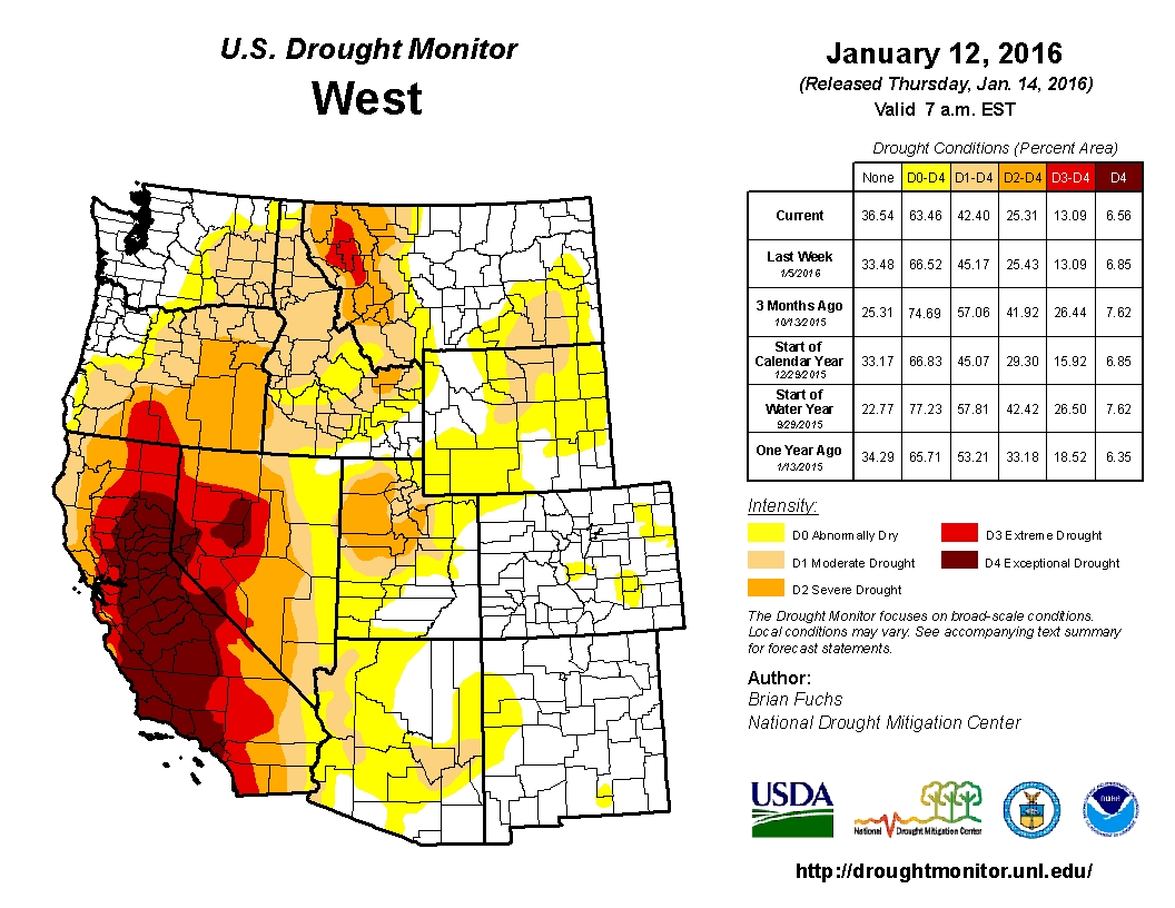
California still had large swaths of exceptional drought at the beginning of 2016 that forecasters hoped the El Niño would wipe out. Oregon and Washington rather than California were the primary beneficiaries of last winter’s storms. As you can see from the US Drought Monitor maps below from the January 2016 and 2017, the drought conditions mostly abated in Oregon and Washington, and are slowly starting to look more favorable in California.
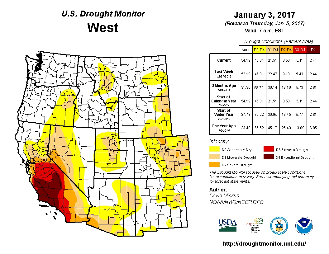
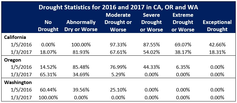
Over the course of the year, Washington became completely drought free, an incredible about-face in drought conditions. At the peak of the Washington drought during the week of October 27, 2015, 100% of the state had some drought conditions and 67.96% of the state was in extreme drought. In almost exactly a year, on the week of November 1, 2016, the state became completely drought free. Oregon faced similar drought conditions at the end of 2015. As of the week of October 27, 2015, 100% of the state had some drought conditions and 67.29% of the state was in extreme drought. Fast-forward to today, and 65.31% of Oregon is drought-free. Further, no areas have worse than moderate drought conditions.
California’s drought has slowly but surely gotten better as well, and long-range meteorologists are quietly hopeful that this winter’s storms, which are off to a good start in many areas of the Golden State, will help to erode the once impenetrable drought. What is causing the weather patterns to change in California’s favor? Will these conditions hold and more importantly continue to reverse the effects of five years of drought in California? I will address these issues in this week’s post.
El Niño shifts to La Niña, but will it hold?
The water temperatures in the equatorial Pacific Ocean play a key role in California’s climate. Extremes in ocean temperatures (both hotter and colder than average) can change the long-term weather patterns across the western United States (and many other parts of the globe for that matter) dramatically. So where are we now? The Pacific Ocean’s average equatorial temperatures have two extremes: when average water temperatures are warmer than normal, we have El Niño conditions; the opposite, or colder than average equatorial water temperatures are referred to as La Niña. Each of these conditions have varying degrees of intensity which scientists refer to as the Oceanic Niño Index. Data from the index show that the winter of 2015-16 had some of the strongest El Niño conditions ever recorded, rivaling some of the readings during the winter of 1997-98. The index peaked in late 2015 and slowly began to fade into weak La Niña conditions as the spring and summer of 2016 wore on. Climatologists were concerned for California’s sake that La Niña conditions usually lead to drier conditions across much of the southern half of the United States. In some areas of the US this has played out, with states such as Georgia and Alabama experiencing extreme drought conditions. But so far, California has seen appreciable rainfall, and some forecasters are hopeful for the remainder of the season.
So far this winter, California (particularly in the north) has seen appreciable rainfall totals. A series of storms have hit the San Francisco/Sacramento area hard, and more are expected to come in the next week. While we have much more winter to go, Sacramento-based National Weather Service forecaster Mike Kochasic said, “Right now we are on pace to have the wettest water year on record. The wettest was 1982-83, and we are on pace or even slightly better than that at this point in the water year. We still have a long way to go though.” A series of storms at the end of 2016 dumped 83 inches of snow at the Squaw Valley Ski Resort, and more storms are on the way. The National Weather Service warns that an “atmospheric river” of storms could bring heavy rain and the potential for flooding across much of northern California this weekend and into next week. Even southern California has enjoyed higher than average rainfall for this time of year. According to the Los Angeles Times, Los Angeles through December 25th received a monthly total of 4.08 inches of rain, 265% of average for the entire month of December. Additional storms around the New Year only added to these totals.
Lots of rain in the 10-day forecast for Sacramento:

Further, some critical reservoirs are at a state where their operators must release water to ensure there is enough room for further flood flows. On the San Joaquin River, the US Bureau of Reclamation announced that on January 5th, it would increase flows out of Friant Dam from 1,250 CFS to 5,000 CFS to provide excess room for expected flood flows. On the Tuolumne River, the US Army Corps of Engineers will increase flows out of the Don Pedro Reservoir to 7,000 CFS again to provide room for flood flows. According to the California Data Exchange Center, the Don Pedro Reservoir is at 75% of total capacity, or 113% of the historical average at this time. Millerton Lake on the San Joaquin River is 73% full, and Lake Shasta, the state’s largest reservoir currently sits at 74% of total capacity.
Why have the climactic conditions in the Pacific defied weather expectations so far? There are a few reasons. The Oceanic Niño Index remains in “weak La Niña” territory with conditions transitioning to more neutral conditions as the winter wears on, according to the Climate Prediction Center. While a strong La Niña condition would increase the likelihood of a drier than normal year in California, neutral conditions like we have now present more of a toss-up as to whether we will have a wetter or drier year. Further, the high pressure atmospheric conditions that blocked most of the storms from hitting California over the last few winters have largely dissipated, allowing atmospheric river weather conditions to enter California and provide ample rainfall so far.
What’s in store for California during the rest of the winter?
While weather conditions have so far been positive, there is still a lot of winter remaining, and a lot of ground to make up in terms of precipitation. The protracted 5 year drought has left behind 18.31% of the state that continues to face exceptional drought conditions. State water officials are remaining cautious about water allocations in 2017. On November 28th 2016, the the California Department of Water Resources announced a 20% initial allocation for the State Water Project and subsequently increased the allocation to 45% on December 21st. In comparison, DWR announced an initial 10% allocation on December 1, 2015, which eventually became a 60% final allocation. Hopefully the state’s reservoirs will continue to fill as more rain falls. However, it will take much more than a strong season of rainfall to reverse the years of damage we have done to our state’s groundwater supplies. So while I am cautiously optimistic about the reversal of some of California’s drought conditions, we have to be realistic about what Mother Nature can and cannot solve over the short-term.