Over two years ago, a Los Angeles Times Editorial stated: “The Salton Sea is a disaster in the making. California isn’t doing anything about it.”
The State of California has finally commissioned this summer (2021) a review of proposals submitted over three years earlier (March 2018). What is the state’s schedule for addressing the rapidly deteriorating conditions at the Salton Sea? The current plan is for the review to be completed by December 2022. And then?
The facts are clear: the rapid decline in Salton Sea’s elevation is accelerating. Continued delay will only mean that the dimension of the challenge in five years, ten years or longer will be substantially greater than the challenge today.
What are the dynamics of the Salton Sea’s elevation?
As reported in a previous post, the long-term, sustained decline of the Salton Sea is a conundrum. Under the terms of the historic long-term water conservation and transfer agreement between the Imperial Irrigation District and the San Diego County Water Authority, the impact of the transfer through 2017 was fully mitigated. So, what other forces are at work?
Let’s update the facts about the Salton Sea’s elevation. The chart below shows daily average elevation by year to show how the Salton Sea’s elevation is evolving over time. There are three eras of trends in Salton Sea elevation since 1987 (earliest year for available USGS. data). From 1987 through 1995, there was an increasing trend in Salton Sea elevation of 0.9 feet per year. Thereafter, a declining trend in Salton Sea elevation began. Between 1996 through 2005, there was a decreasing trend in Salton Sea elevation of 0.11 feet per year. The decline in Salton Sea elevation accelerated after 2005 to a rate of 0.60 feet per year through the year 2017. The elevation of the Salton Sea has been in free fall for the past fifteen years.
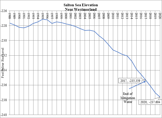
The variability of Salton Sea’s elevation around these trends is instructive (see chart). For the USGS historic record 1987-2017, the variability of the actual Salton Sea elevation around trend ranges from a low of -0.5 feet to a high of +0.8 feet. With the end of mitigation water being delivered into the Salton Sea in 2018, the deviation below trend declined by 0.962 feet in 2018, 1.323 feet in 2019 and 1.362 feet in 2020. In other words, the actual decline in the Salton Sea’s elevation in 2018 was 2.6 times the trend declines from 2006 to 2017 (trend decline of 0.6 feet plus a deviation below trend of another 0.962 feet), in 2019 3.2 times the trend declines from 2006 to 2017, and 3.3 times the trend declines from 2006 to 2017.
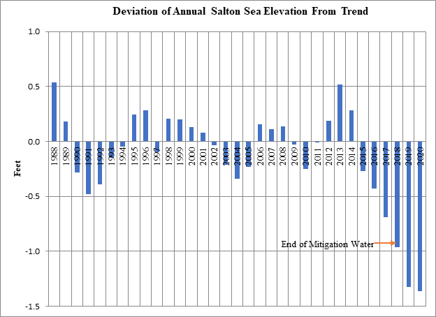
Does this signal an acceleration in the decline of the Salton Sea’s elevation with the termination of mitigation water delivered to the Salton Sea? From a statistical perspective, a new trend cannot be confirmed with a few data points, although the run of six years of deviations below trend with an acceleration of declines after the delivery of mitigation water ended may be “some type of signal.” Continued state inaction should eventually provide enough data to support a statistically robust estimate.
In the meantime, public health costs accumulate and environmental collapse marches on.